
The extent of this "gift" of land (which required an annual rent to be paid to the crown) can be seen around Aberdeen today. Often mistaken for milestones, the engraved numbered stelae which lie hidden in plain view around Aberdeen mark the boundary between the gifted estate and the hinterland beyond - Kincardine to the south, Mar to the west and Buchan to the North. Bruce had occupied Aberdeen in 1307 and 1308 while he laid waste to a large part of that hinterland.
<<<<<<<<<<<<<<<<<<<<<<<<<<<<<<<<<
http://otheraberdeen.blogspot.com/2011/01/march-stones-37-to-39-abd.html
The Harrying of Buchan was a devastating event for this area, characterised by its (surprisingly modern) ruthlessly systematic nature. This was a policy, managed and executed with businesslike efficency; entire towns like Ellon were completely eradicated, livestock and crops were burned in the fields, infrastructure was dismantled and dissipated. Some historians say that so complete was the destruction that the innate and potential wealth of Buchan was damaged for centuries after. A terrible and exceptional act of vengeful spite, unparalleled in these islands before or since.
Small wonder the Aberdonians cowered and offered Bruce whatever he wanted. The fearful and pusillanimous capitulation of Aberdeen's burghers (who had been loyal to the English crown until the pogrom in the hinterland) no doubt, in time, pricked Bruces' conscience and lead to his eventual largesse. According to the Aberdeen City and Shire website, the ordinary people of Aberdeen also "furnished" Bruce with "large supplies" of cash, food and other goods. Under what levels of terror and sword-edge compulsion was this "furnishing" obliged?
<<<<<<<<<<
<<<<<<
 |
| Pylon |
 |
| Stela |
The boundary stone marked "52 ABD" is tucked up against a wall and fence at the back of the pavement on the north side of Smithfield Road, just up the hill from its junction with Clifton Road. As we walk up the steep hill, we notice that the boundary describes a narrowish tongue of land descending to the river Don at Scatterburn, then sharp back uphill, leaving Woodside outwith the boundary.
------####-----
>>>>>>>>>>>
<<<<<<<<<<<<
http://canmore.rcahms.gov.uk/en/site/19997/details/aberdeen+hilton+lang+stane/
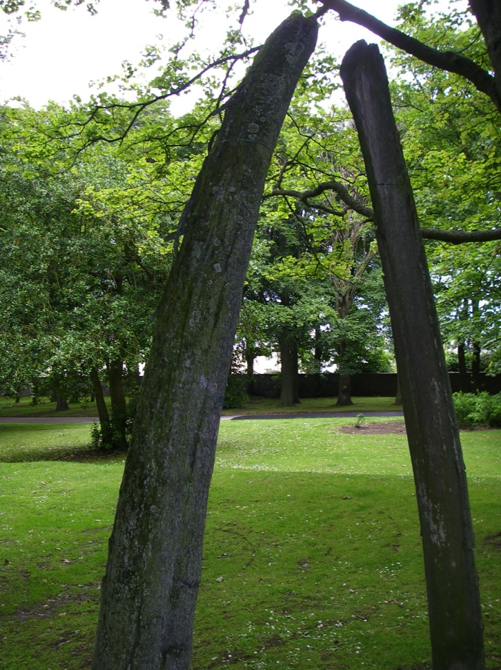
 A free-standing block of granite, c.9 to 10 feet in height, which Dr Simpson believes to be a Bronze Age standing stone. It now stands in the grounds of Hilton School and may have been moved when the school was built (Anon 1949), but if so it was replaced in its original position (information from Dr W Douglas Simpson, Librarian, Aberdeen University). Anon 1949.
Visited by OS (JLD) 10 September 1952.
This standing stone is situated on a gentle ENE-facing slope at an altitude of about 80m OD. It stands within a school playground at adjacent to the gates onto Hilton Drive.
(Newspaper reference cited).
NMRS, MS/712/83, visited 11 January 1991.
 This large granite standing stone, which until recently stood within the grounds of Hilton School, now forms a landscape feature in a new housing development. It measures about 1.5m in breadth by 0.9m in thickness at ground-level and 2.95m in height, and its broad face is aligned WNW and ESE. A scar on its SSW corner suggests that the top of the stone has been broken off.
The stone, which is enclosed by narrow iron railings set on a circular plinth, is depicted on both the 1st and 2nd editions of the OS 6-inch map (Aberdeenshire, 1869, sheet lxxv; 1902, lxxv.NW).
Visited by RCAHMS (JRS), 19 June 2002.
>>>>>>>>>>>>>
/////////

Half-a-kilometer away we can hear the continual traffic rumble and swish of Anderson Drive, all the more audible since the removal last year of the verge-side shrubbery which had acoustically shielded residential areas from the carriageways since the 1960's. The line of the March Stone boundary draws us up Hilton Road between the the three hectares of open space at Stewart Park and the abandoned Rosehill Quarry which mirrors it opposite. Again, the area is curiously quiet. No-one plays the all-weather tennis courts, no-cricketers in the Victorian pavilion by the oval. No children kick footballs on the grassy extents of the park; a philantrhopic gift from the widow of a Woodside merchant. Other than us, only those handful walking their dogs give themselves the permission to be out in the air, walking in the neat park and wild overgrown abandoned quarry.
oooooooooo
 |
| Presented to the park by the Captain of the Arctic whaler "Benbow" in 1903 |
>>>>>>>>>>>>>>>>>>
http://www.dailykos.com/story/2005/03/21/100828/-Brain-Dead-Molybdenum-and-Whale-Oil-tell-our-sorry-tale
In order to obtain historical evidence for price trends, one needs to examine a case where a non-recyclable resource went through a complete Hubbert cycle worldwide. There are no previous examples of a mineral resource that has done so. In fact, crude oil may turn out to be the first, which incidentally may be one of the reasons why the concept of "peak oil" is so difficult for many people to grasp.
A resource does not need to be a mineral one to show a Hubbert curve. A biological resource which is produced (or "extracted") much faster than it is replaced may also follow a bell-curve. Historically, there have been several cases of terminally depleted biological resources. The whaling industry of the 19th Century is a good example, as already noted by Coleman (Non Renewable Resources, Oxford University Press, 4(1995) 273).
(...)

From the figure [above], it is evident that the production of whale oil followed a bell-curve according to Hubbert's theory, modelled with a simple Gaussian curve, albeit showing strong oscillations. These data are in excellent agreement with the report on Right Whale abundance by Baker and Clapham (Trends in Ecology and Evolution Vol.19 No.7 July 2004), indicating that the fall in production after the peak was caused by depletion and not by the switching to different fuels.
(...)
>>>>>>>>>>>>>>>
<<<<<<<<<<<<<<
A DESCRIPTION OF WOODSIDE IN 1894
==============
The atmosphere is charged with granite dust; factory stacks and quarry tips mingle incongrously with woods and pastures. From the Cruvies to Stoneywood, the banks of Don are dotted with factories in all the stages between full activity and silent decay.
>>>>>>>>>>>>>>
Abridged from "Woodside Nae Mair!"
Fullerton Court and Murray Court Oral History Group
Frae a the Airts to Haudagain
Dorothy Crichton
In 1798, Lord George Gordon Noel Byron, celebrated English poet, was a young lad living a short time in Woodside with his old nurse, Agnes Gray. She lived on the first floor of the old house at 719 Great Northern Road. The house was demolished in the 1950's to make way for the dual carriageway. The exact date of Byron's visit and length of stay in Woodside isn't known. But when there he 'fell in love' with an attractive girl named Lexy Campbell who lived with a very respectable spinster - Nelly Calder. Poor Lexy lost face by this affair and her subsequent history was unfortunate.
#################
Across at last, we would be taken by the pavement round a pointless loop to get to where we want to go. Instead, we use the well-worn desire-line path which crosses the grass and bisects the shabby shrubbery to reach the top of Smithfield Drive.
 |
| 54 ABD |
------------//////////////---------------------------------------
>>>>>>>>
.
No comments:
Post a Comment