All good stuff on our favourite architecture site Urban Realm - we've had correspondence with one of their bloggers, another psychogeographer of Aberdeen, Mark Chalmers.
His blog is recommended. We like his angle of attack.
Here he is:
Mark Chalmers blog
Tuesday 31 August 2010
Monday 23 August 2010
Public Art - Elrick Hill and Tyrebagger Woods - More.
Lots of public art to find as you explore this Forestry Commission site. Here's just a few examples:


March Stones 26 and 27 ABD - Brotherfield
In common with other cities, notably Washington DC, the historic borders of Aberdeen are marked with boundary stones - The March Stones. ("March" being mid-Scots for "boundary" or "border").
The March Stones are said to mark the boundary of lands granted to the Burgh of Aberdeen by Robert the Bruce.
 |
| Click for a bigger version. |
Stone 26 ABD is at the confluence of the Ord Burn and Silverburn.

Stone 27 ABD is one of the more recently-made stones, its predecessor presumably having been swept away by the Ord Burn which it borders. There had been a fair bit of rain in the few days before we visited, and the burn was roaring in spate. Aside from the style of the carving, one aspect of the newer stones is that they do not follow the convention of facing inwards, towards the burgh. That is, in order to read the inscription on the older stones, one must be standing within the border.
In order to see the inscription on Stone 27 ABD, one must be standing outwith the border. Not that it really matters.

Stone 27 ABD used to mark an artifact known as 'The Ringing Stone'. The origin of the name has been lost in time, along with the stone itself, but stones which 'ring' with a tone when struck are not uncommon - there are 'rock-gong' sites all round the world. Indeed, the recumbent stone at the Tyrebagger stone circle is a 'ringing stone'. There's an article in this week's New Scientist about the importance of acoustics and sound design to our prehistoric ancestors. The article touches on 'rock gongs', so it's worth a read in this context.
While we were in the area, we took the opportunity to re-visit the site of Stone 21 ABD and got a proper photo of it. Cattle-saliva and bird-lime smeared though it is...

Then, as you can see, the weather closed in on us...
 |
| Click for a bigger version. |
From Beans Hill, you can see all the way to Lochnagar. Weather permitting.
Public Art on Elrick Hill - The Truth Is Out There
Looking for March Stones in the fold between the north slope of Brimmond Hill and the south slope of Elrick Hill, we caught sight of this collection of artifacts from a distance.
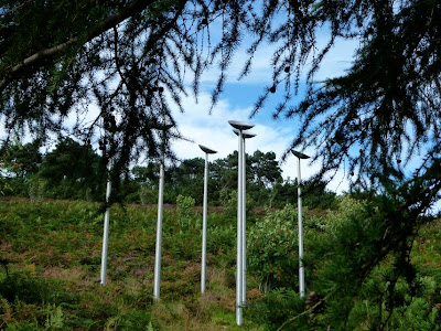
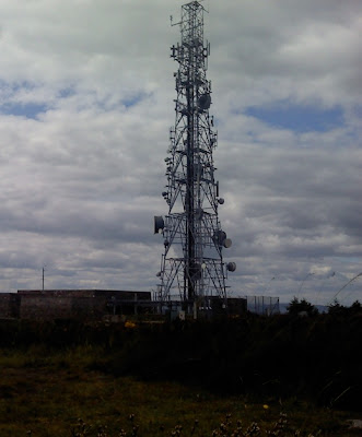
The dish-shapes immediately put us in mind of the dishes on the mast-structure on the summit of Brimmond Hill which they look across the valley of the Green Burn towards. The mast atop Brimmond Hill is part of the microwave relay network.
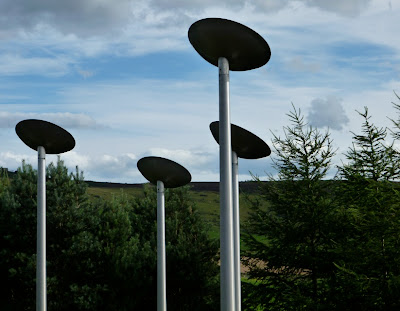
The saucer-shapes made us think of other 'out-there' stuff we've seen around here:

The dish-shapes immediately put us in mind of the dishes on the mast-structure on the summit of Brimmond Hill which they look across the valley of the Green Burn towards. The mast atop Brimmond Hill is part of the microwave relay network.

Getting closer, we were struck by the drama of this sculpture on its hillside location.


The saucer-shapes made us think of other 'out-there' stuff we've seen around here:

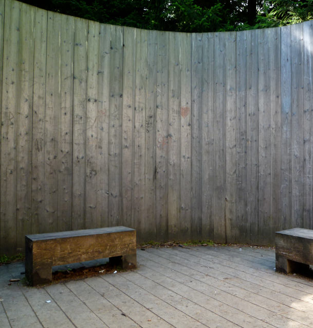
Public Art at Tyrebagger Woods.
We're ashamed to admit that we hadn't even heard of this place until the other day when we read that our favourite quango Aberdeen Greenspace had done some work on path consolidation there - so off we went and we were delighted to 'discover' this installation (among many others).

When we came across it, we were first reminded of the sort of palisades built by British settlers in places like Virginia and Newfoundland during the 17th century.

Then, as we explored the concentric structure we were reminded of other concentric defensive structures, like the pre-historic forts and earthworks around Aberdeenshire. Places like Bruce's Camp, and Hill of Christ's Kirk. There are many others.

As the concentric structure drew us in, we were delighted to find the catwalk/plank/ramp which provides access to the inside.


Bench seating inside gives a relaxed haven, open to the sky, to sit, relax and listen to the sounds of the forest.
Wednesday 18 August 2010
March Stones 21 to 25 ABD - Beans Hill and Silver Burn - The Bypass Lands
Continuing our exploration of the border of the medieval burgh of Aberdeen "The Marches" (march=border) we find ourselves at Beans Hill, between Countesswells and Peterculter. The border is marked by 67 'March Stones'
There's plenty information available online about the March Stones. Aberdeen City Council have a leaflet which details a couple of walking trails. You can download a PDF here. (Health warning - there are a couple of errors on the leaflet).
The Leopard mag has an excellent article about the history of the March Stones which we recommend.
Anyhow; Beans Hill. It's a picturesque and serene area, but won't stay that way for long as this where the Aberdeen Western Peripheral Route will skirt the city on its way from Peterculter to Kingswells.

We recommend a visit if you can, before the character of the area is changed forever. Bone up on the Scottish Outdoor Access Code (PDF), get some old clothes and sturdy shoes on and off you go!
We left off last time with Stone 20 near Westfield Lodge, which is a very strange place.

Stone 21 is in the middle of a field, which, unfortunately on the day we visited was hosting an herd of bullocks. As we were, ahem, quite brightly dressed in our mountain bike gear, we didn't fancy our chances intruding on their space, so we'll have to make do with this telephoto and digitally zoomed image of the back of the stone. Let's say that this is a placeholder image, and we'll return for a proper photologging of the stone when we can. A bit disappointing.

Edit:
Here it is - no bullocks in the way this time:

Stone 22 is actually in the same field, but the bullocks were a couple of hundred metres away, over a rise and out of line-of-sight, so we vaulted the dry stane dyke for this shot. You can see that the bullocks have been licking the stone. As they do.

From there, it's a bit of a trudge up Beans Hill. Looking back to the south-west down the route of the march-line:

That photo was taken from a site which will become the western embankment of the AWPR - where it intersects the greenery in the centre of this drawing.

Stone 23 is at the summit of Beans Hill. Unfortunately you have to negotiate this labyrinth of barbed wire and gorse to get there. Gloves are a really good idea.

We were looking forward to finding stone 23, as it is described as having a 'saucer-marked' stone next to it. These ancient stones are part of the natural geography of the landscape and are prominent features, so it was natural for those setting land borders to use them, along with water-courses and other features, as markers which helped define the border. The 'saucers' are depressions carved or ground into the natural stone. No-one's really sure what their function was, but some speculate that they were filled with molten lead into which the city's coat-of-arms was impressed.
Here's Stone 23 at the summit. It looks like that's the more ancient 'saucer-marked' stone beneath the ABD marked stone. A previous visitor has peeled back some moss to reveal more of the stone, but we can't see a saucer mark here.

Hold on, what's this?

The saucer-mark is about four feet from the ABD stone. It's covered with a thick coat of moss, which is beginning to form a topsoil layer which grass has colonised.


Stone 24 is over the summit of Beans Hill and down the slope towards the Silver Burn. It's close by North Westfield house. The couple who live there were delighted to chat.

Stone 25 is accessed from East Brotherfield farm. Again, the farmer was delighted to chat and pass the time discussing the stones and the dreaded coming of the bypass. It really is a delightful area, and we can't help but feel for the residents who's tranquility will be shattered and life changed forever by the building of the new road.

Stone 25 is on a hillock in a field of cows. Young heifers this time, so nothing to fear. But if you go there - please be sure to speak with the farmer first. Very important.

Unlike at stone 23, where it's covered in moss and not at first apparent, the saucer stone at 25 is prominent and rather obvious.
Behind the saucer stone, we find a poignant memorial to an earlier march-tramper.

There's plenty information available online about the March Stones. Aberdeen City Council have a leaflet which details a couple of walking trails. You can download a PDF here. (Health warning - there are a couple of errors on the leaflet).
The Leopard mag has an excellent article about the history of the March Stones which we recommend.
Anyhow; Beans Hill. It's a picturesque and serene area, but won't stay that way for long as this where the Aberdeen Western Peripheral Route will skirt the city on its way from Peterculter to Kingswells.

We recommend a visit if you can, before the character of the area is changed forever. Bone up on the Scottish Outdoor Access Code (PDF), get some old clothes and sturdy shoes on and off you go!
We left off last time with Stone 20 near Westfield Lodge, which is a very strange place.


Edit:
Here it is - no bullocks in the way this time:

Stone 22 is actually in the same field, but the bullocks were a couple of hundred metres away, over a rise and out of line-of-sight, so we vaulted the dry stane dyke for this shot. You can see that the bullocks have been licking the stone. As they do.

From there, it's a bit of a trudge up Beans Hill. Looking back to the south-west down the route of the march-line:

That photo was taken from a site which will become the western embankment of the AWPR - where it intersects the greenery in the centre of this drawing.

Stone 23 is at the summit of Beans Hill. Unfortunately you have to negotiate this labyrinth of barbed wire and gorse to get there. Gloves are a really good idea.

We were looking forward to finding stone 23, as it is described as having a 'saucer-marked' stone next to it. These ancient stones are part of the natural geography of the landscape and are prominent features, so it was natural for those setting land borders to use them, along with water-courses and other features, as markers which helped define the border. The 'saucers' are depressions carved or ground into the natural stone. No-one's really sure what their function was, but some speculate that they were filled with molten lead into which the city's coat-of-arms was impressed.
Here's Stone 23 at the summit. It looks like that's the more ancient 'saucer-marked' stone beneath the ABD marked stone. A previous visitor has peeled back some moss to reveal more of the stone, but we can't see a saucer mark here.

Hold on, what's this?

The saucer-mark is about four feet from the ABD stone. It's covered with a thick coat of moss, which is beginning to form a topsoil layer which grass has colonised.

The saucer stone is really quite large. The biggest we've come across so far. It came as a surprise to discover that we'd been standing on it for some time.

Stone 24 is over the summit of Beans Hill and down the slope towards the Silver Burn. It's close by North Westfield house. The couple who live there were delighted to chat.


Stone 25 is on a hillock in a field of cows. Young heifers this time, so nothing to fear. But if you go there - please be sure to speak with the farmer first. Very important.

Unlike at stone 23, where it's covered in moss and not at first apparent, the saucer stone at 25 is prominent and rather obvious.
 |
| Can you see the saucer-hole? |
Behind the saucer stone, we find a poignant memorial to an earlier march-tramper.

The Stately Drives of Pitmuxton
Aberdeen is Tycoon Town: if you're not a tycoon already, you will be soon. As everyone knows, tycoons usually live in lovely big houses, with grand, sweeping, tree-lined drives. It's one of the things which makes rich people so very splendid!
Pitmuxton is a part of Aberdeen where once-grand houses bordered the main roads to the west and south, their sweeping, stately tree-lined drives impressing the high status of the estate-owners upon all who had eyes to see. Today, these houses and their drives are largely gone along with the social order which brought them into being.
Gone though the stately drives of Pitmuxton may be, if we look closely, we can see the effect of this old order upon the psychogeographical environment of today:
Anyway, so much for the past! What about our up-and-coming tycoons of tomorrow?
Well, it's great that planning policies in Aberdeen allow our arriving class of aspirant tycoons to rehearse their tycoon-hood by building themselves pocket simulacra of the once-stately drives of Pitmuxton.
The aspirational would-be tycoons of Pitmuxton are free from these petty planning niggles; free, as homeowners should be, to do what they like with their own property. Front gardens are soooooo time consuming anyway, who needs them? Some nimby naysayer meanie greenie extremist moaning minnies complain that converting front gardens to parking space a lovely driveway can be unsightly and restricts informal surveillance. They say that it radically alters the streetscape and has a negative impact on the character of the town. They moan that increased water-run off will overload drainage channels, they whine that the loss of urban green space will impact biodiversity and they bleat that pedestrians are inconvenienced by the creation of uneven pavement crossovers for cars. And lots of other stuff. There's a bunch of all this moaning here: 43 Reasons Not To Pave. Honestly, what a lot of rubbish! We think they're just jealous. Really, can't they afford a nice car?
We can't understand why everyone doesn't do it. They must be 'bee-lovers' or poor or weirdos or something.
Unfortunately, some of our proto-tycoons who're just starting out on their arc of success are obliged to live in starter-flats, which have no gardens to convert. In order to preserve appearances and not park on the road (people who use on-street parking look poor!) we recommend PaveParking:
 |
| 1862 |
Pitmuxton is a part of Aberdeen where once-grand houses bordered the main roads to the west and south, their sweeping, stately tree-lined drives impressing the high status of the estate-owners upon all who had eyes to see. Today, these houses and their drives are largely gone along with the social order which brought them into being.
 |
| 1867 |
 |
| This is the drive to Broomhill House today. The house and outbuildings are gone - replaced by lockups. But the tree-lined drive remains - more stately than ever. |
 |
| This is the gate to Newlands House today. The house remains, but is today surrounded by 1970's flats and bungalows. |
Well, it's great that planning policies in Aberdeen allow our arriving class of aspirant tycoons to rehearse their tycoon-hood by building themselves pocket simulacra of the once-stately drives of Pitmuxton.
 |
| Nice, clean lines. No dirty plants or insects or anything. We're perplexed that they've chosen to retain the 'garden refuse' wheelybin. There can be no filthy 'garden refuse'! |
Being on the 'wrong' side of Great Western Road as it is, the vast majority of Pitmuxton is subject to none of the pesky requirements imposed upon hard-pressed homeowners by the strictures of so-called "conservation zone" planning policy.
 |
| The wheelybins balance the composition created by the pot-plants which flank the front door. The whole picture is completed by the tarmac crossover which creates a thrilling 'rollercoaster' effect for pedestrians. |
 |
| This driveway is actually pre-fabricated sheets of plastic. Which conveniently matches the plastic plants at the front door! |
 |
| There's room for at least two silver-grey German cars there for goodness sake! |
 |
| All those flowers are sure to attract dangerous bees and other filthy wildlife - ugh! And look at that mess on the floor! |
 |
| How to do full PaveParking in Pitmuxton |
Subscribe to:
Posts (Atom)